
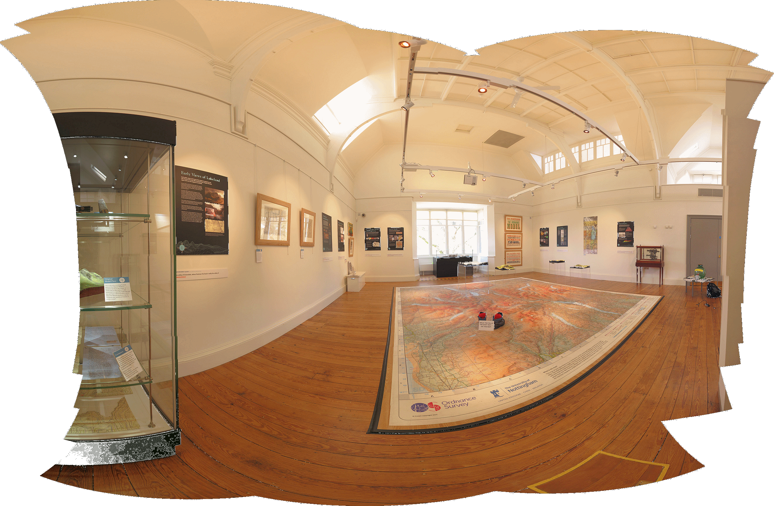


Gallery Plan < Back to Top >
Descriptions of the various components of the exhibition can be viewed via the labels on the gallery plan (right) or in sequence by scrolling down.
Background < Back to Gallery >
Early visitors to Lakeland may have seen paintings or drawings but maps were scarce and didn't offer a detailed overview of the landscape. Relief models gained in popularity and provided clear aerial perspectives but were quite generalised. It was only through advances in map making that the contour line began to be used on maps and provided the basis for more accurate and detailed landscape representation. Click on a panel below to open a larger PDF version.


The Mayson Model < Back to Gallery >
Keswick photographer Henry Mayson and brother Thomas saw an opportunity to use the maps produced by Ordnance Survey to create a relief model larger and more accurate than any other in the area and the would target the hoards of visitors arriving on the new railway.

Click on image above to open up PDF
Reconstruction of Mayson's model as it might have looked in the Lake Road studio
A number of historical objects that had been discovered in Mayson's studio in the late 1970s by a local bookseller were aquired. These provided valuable detail about how the model was made and the role it played in the visitor experience. These were displayed around the gallery space and complemented the information panels which described the background to the Mayson model.
Historical Objects (including posters) < Back to Gallery >

The original poster which was displayed at local guest houses around Keswick.

One example of several posters that were found which shows how the model was advertised as being bigger and better than others (eg: the Flintoft model)

A single tile representing one of the 210 square foot tiles that made up the original model was discovered. This would be a duplicate, perhaps created by the scultor to demonstrate what the final model could look like, and perhaps used by Mayson as a portable demonstration.

Some of the original Ordnance Survey maps that had been used to make the model were found. Some of the contours were marked up in colour and pin holes marked locations of settlements and other features transferred to the model.
The original letter commissioning the model shed light on how the Mayson brothers were meticulous in specifying the work flow based upon blocks of Ordnance Survey map sheets. The letter also mentioned the need for a 'set of perfect moulds for future use'.
Negative Moulds < Back to Gallery >
The most important discovery was a set of negative moulds. Of an original total of 210 (15 feet by 14 feet) 142 have survived.


The mould in the centre was an example of one which still had side panels designed to form a reservoir of plaster which would set to form a flat bottomed positive model.
Click on image above to open up PDF
Reconstruction < Back to Gallery >

In order to study the model in more detaill we used a series of digital technologies to analyse the surface of the moulds.
The first stage was to capture the surface of each mould in three dimensions using a laser scanner. This was undertaken using a high resolution scanner from the Digital Humanities Centre at the University of Nottingham under the guidance of Dr Katharina Lorenz.. This resulted in a ‘digital surface model’ for each mould, being represented by hundreds of thousands of 3D points, known as a ‘point cloud’.
The scans were then processed using a Geographical Information System (GIS) - specialist software for manipulating spatial data. Each was digitally inverted to show how a positive surface would look when cast out from the equivalent mould.
For a selection of moulds the digital data was converted into a form suitable for controlling a milling machine. This form of 3D fabrication was perfect for landscape surface models where the undulations of the ground are carved out of modelboard by a computer-controlled drill bit. The milling work was led by Sarah Thomas at the Centre for 3D Design, School of Architecure and the Built Environment, The University of Nottingham.
Click on image above to open up PDF
Floor Map < Back to Gallery >
It was not possible to re-create the whole of the Mayson model within the time and resources available so to give visitors an impression of the size of the original model a decision was made to produce a floor map at the scale of the model. The intention was to produce a very clear relief effect but also to offer a high level of information content so people could identify places and routes. A custom backdrop layer was created with a GIS by fusing relief colour bands with a hillshade effect. This image was set behind the familiar 1:50,000 scale Landranger mapping by the cartography unit at Ordnance Survey. The map proved extremely popular with visitors using it to orientate themselves and share stories of walks. To convey detail of how the model may have looked, a number of replica models were positioned over the floor map on clear plinths.

Projected Model < Back to Gallery >
A set of four replica tiles centred on Keswick were joined together to form one 60cm x 60cm model the surface of which was sprayed white in order to project various maps onto it. This was an example of the Projection Augmented Relief Model (PARM) technique and was used here to act in part as a You-Are-Here map but also to show visitors the route Victorian tourists would have taken when leaving the train and walking down past Mayson's building on the way to the Crow Park 'viewing station' by Derwentwater. The poster board (left) shows some alternatice map layers that were used in the projection and the photo (right) shows the PARM situated over the floor map.


Click on image above to open up PDF
Replica Models < Back to Gallery >
Three digitally reconstructed tiles were produced in such a way as to give visitors an idea of the level of detail that would have been present in the original Mayson model. The original sample tile described earlier gave clues as to the way the model would have been coloured. Inspiration was also taken from some of the Swiss models from the same period that had been viewed during 2014 during a visit to Zurich. Such models may well have been studied by the sculptor Raphaelle Monti and the detail in both settlements (below centre) and craggy rock faces (below right) was something that was to influence the choise of tile used in the Mayson replicas.

Click on image above to open up PDF


Windermere - This tile was chosen to show how Windermere and Bowness had expanded since the 1860s when the mapping was created, with the modern day floor map showing how these settlements had grown together. This tile also demonstrated the techniques used for modelling buildings.

Langdale - This tile was chosen as it is one of the most popular and recognisable locations for visitors, particularly walkers and climbers. It also demonstrated the techniques used for modelling crags.

Mardale - This tile was chosen as it showed one of the major chamges in landscape that had occured in the Lake District since the Mayson model was created, the flooding of Mardale to form Haweswater. The floor map gave a direct comparison to the model above which was based upon the Mayson model, in turn based upon the 1860's maps.
Digital Models < Back to Gallery >

Click on image above to open up PDF
The innovations shown in the Mayson model were complemented in the exhibition with some examples of how landscape models are made today. THis included an overview of some of the ways that height data is captured remotely from aircraft rather than by ground surveying.
The unique appeal of physical landscape models was central to the Grandest Views exhibition but for context some of the capabilities of digital landscape modelling were illustrated through a series of images on the wall.

There are many options for creating digital models of buildings. This image showing a model of the museum was created using the free architectural design package ‘SketchUp’ which allows objects to be drawn in ‘3D space’ and textured with photographs

Digital models often now include detailed interiors. The example shown here is the 3D model of this gallery space used in planning the exhibition. Every object in the scene is to scale, and can be easily moved around to experiment with layout ideas.

Digital landscape models can be made up of many objects, including the ground, trees, buildings and lakes. Each object has its own material properties which can result in quite photorealistic scenes, as seen here in the reflections on the Derwentwater ‘object’.

With more powerful mobile devices we can take digital models into the field, to augment our view of the real landscape. Here we see a reconstruction of the view from Crow Park looking into Borrowdale as it may have appeared during the ice age 15,000 years ago.

Historical landscape scenes can be reconstructed and shown in a realistic fashion. The danger here is that believable scenes can be generated even though the evidence may be thin. Was this really what the retreating glaciers in the Newlands Valley looked like?

Alternative or future scenarios can be presented either as snapshots or animated sequences. Here we show the unlikely event of water draining from Wastwater, the deepest lake in England! The model included lake bed contours and a lake surface object.


Understanding the Earth beneath our feet is difficult. Here we see geological cross-sections looking north over Cumbria and beyond. The volcanic dome under central Lakeland is highlighted in red on the sections. Data from Ordnance Survey and the British Geological Survey (BGS) © NERC 2015. All rights reserved.
Computer games often use highly detailed landscapes which are often imaginary. The popular game ‘Minecraft’ shown here uses simplified landscapes which although are usually fictional, can also be based on reality, here using the free Ordnance Survey ‘Terrain 50’ data.
Animation < Back to Gallery >
One of the key capabilities of digital landscape modelling is the ability to communicate many different perspectives on that landscape. An animatied fly-through based upon the same geographical area covered by the Mayson model was created and projected onto the gallery wall. In demonstrating a number of different techniques it also linked to other displays in the gallery, for example showing a virtual model of the Mayson model, and visiting the Langdale and Windemre tiles.
The video can be viewed here >
3D Printing < Back to Gallery >
Today the process of building physical models is potentially easier given not only the availability of digital landscape data but also several options for 3D fabrication.
The milling technique which subtracts layers of material from a block of modelboard has already been demonstrated through its use in creating the replica Mayson tiles.
Also on display were several examples of additive 3D printing, where layers of material (for example plastic or plaster powder) are built up to form a 3D model. The example on the right shows a physical model printed from Ordnance Survey landscape model with colour aerial photography. These models were created in collaboration with the Centre for 3D Design at the University of Nottingham.

Final message of the exhibition...
Despite the many benefits of using digital landscape models and technologies for displaying them, physical models like the Mayson model still have an important role to play today. They effortlessly provide visitors with an overview of a landscape, in glorious ‘Full Definition’ human stereo vision!